Carved into the heart of the Picos de Europa, the Ruta del Cares is one of Spain’s most breathtaking hikes. This legendary trail winds through a dramatic limestone gorge with sheer cliffs almost 2,000 meters high. Here’s all you need to know.
Nestled deep in the rugged Picos de Europa National Park in northern Spain, the Ruta del Cares is easily one of the best hikes we’ve done in Spain.
The path follows the Cares River as it clings to a dramatic gorge linking the Asturian village of Poncebos with Caín in León.
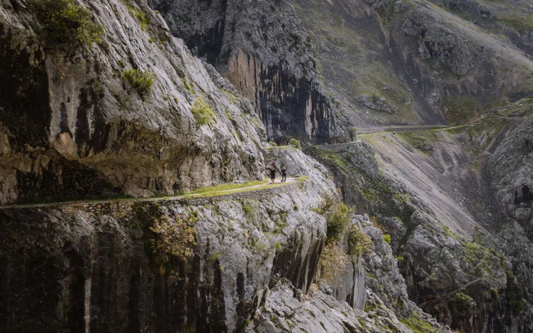
Set into the walls of the cliffs, hundreds of feet above the river, the path is a marvel of engineering. At times, it’s only a few metres wide, snaking along near-vertical walls with incredible views all around you.
Although there are precipitous drops on one side, the trail is very flat and still wide enough to feel quite safe.
If you find yourself in this part of Spain, we highly recommend this hike.
In this guide, you’ll find everything you need to know about hiking the Ruta del Cares: detailed trail descriptions, a map, safety tips, and practical advice.

RUTA DEL CARES OVERVIEW
The Ruta del Cares is a mountain hike that runs between the villages of Poncebos and Caín in the Picos de Europa in northern Spain.
We hiked the Ruta del Cares in May when the weather was mild, but a bit overcast; the perfect conditions for this fairly long hike.
It’s an 11.5-kilometre one-way hike, which takes about 3 to 3.5 hours. However, there is no convenient public transport to return to the starting point, so you must hike back the way you came.
This makes the whole walk around 23 kilometres, which took us around 7 hours to complete.
WHERE TO START?
As a one-way hike, you can either start in Caín or Poncebos. Whichever starting point you choose, you’ll need to walk back the way you came.
We started the hike from Poncebos, and we recommend you do the same for several reasons.
Firstly, starting at Poncebos means you’ll get to Caín around lunchtime, and the restaurant options and scenery are much better than in Poncebos.
Secondly, if you stay multiple nights, Poncebos is a better base for seeing more of the area, which you can read about in our Picos de Europa guide.


RUTA DEL CARES MAP
Below, you can find a map of the hike. The route is marked in red.
USING OUR MAPS. Click on the top right corner to open in the Google Maps app. Click on the star to save to your Google account.
HOW TO GET TO THE TRAILHEAD
The Ruta del Cares Trailhead is a ten-minute walk from the village of Poncebos.
There is only limited roadside parking at the trailhead, so we highly recommend staying the night in Poncebos and grabbing a parking spot when you arrive the night before.
IF YOU’RE STAYING IN PONCEBOS
Paul and I stayed at Arcea Mirador de Cabrales, an excellent value 2-star hotel in Poncebos. It has good-sized rooms and breakfast is included. They also serve dinner each night, which is handy given the remote location.
The hotel is a 10-minute walk from the beginning of the Cares Trail. It’s rightly popular with hikers, so you should try to book as early as possible.
IF YOU’RE STAYING IN LAS ARENAS DE CABRALES
The other option is to stay in Las Arenas de Cabrales, where you’ll find a higher standard of accommodation. However, you will need to drive to the trailhead in Poncebos (10 minutes), and finding a parking spot can be difficult.
That should not be a problem in the low season, but we’d recommend setting off early. In the high season, however, (Easter holidays and early June to mid-October), the road from Las Arenas to Poncebos is restricted to help alleviate the traffic.
To get to the start of the hike from Las Arenas de Cabrales in the high season, you’ll need to take the shuttle bus that runs hourly from 8 am to 8 pm. At the time of our visit, the cost was €3. You can pick up the bus from either Las Arenas or the parking lot at Ovar.
If you decide to stay in Las Arenas, here are a couple of good options.

Send Me Somewhere is our newsletter with 3 destinations to book right now—plus deals and expert tips. Delivered to your inbox every Friday.
Hotel Villa de Cabrales – This comfortable, modern hotel is in a renovated country home that retains much of its charm. It’s located in the centre of Las Arenas and offers easy parking across the street. Good bars and restaurants are nearby.
Hotel Picos de Europa – The rooms at Hotel Picos de Europa are modern and spacious, and the outdoor terrace and pool are the perfect place to unwind after a day in the mountains.
It’s a convenient base with easy parking outside and all the facilities of Las Arenas on your doorstep.

RUTA DEL CARES HIKE
- Distance – 11.5km each way (23 km round trip)
- Time – 6 hours 30 minutes to 8 hours including breaks
- Elevation – About 650m of gain and loss
- Difficulty – Medium – nothing difficult, but a long day hiking
PONCEBOS TO LOS COLLAOS (1 hour)
From the hotels in Poncebos it is a 10-minute walk along the road to the trailhead. You will go through a short tunnel and start to pass the roadside parking.
Ignore the sign left to ‘Ruta de la Canal del Texu’ and shortly afterwards you will reach a wooden information point. Turn sharp right, and head slightly uphill following the route ‘Senda del Cares / Caín’.
This route is called PR – PNPE – 3 and it indicates 3 hours to get to Caín. The path soon hairpins left, and from here it is almost impossible to get lost. The trail is well trodden and very clear.
The first hour is the hardest. The rocky path gradually climbs and climbs, zigzagging through some old ruins before finally reaching Los Collaos.
This is the highest point along the trail and views suddenly open up. You can see the trail winding in front of you as it heads deeper into the gorge.


LOS COLLAOS TO PUNTE BOLÍN (1 hour 45 minutes)
At Los Collaos, the trail levels out and soon begins to descend. This marks the beginning of the most dramatic section of the hike. The trail narrows and clings to the edge of steep valley walls, with a precipitous drop on one side.
The path is pretty wide (1.5 to 2 metres) and relatively flat, so unless you have a strong issue with heights, it should feel pretty safe.
The trail heads through several tunnels. On our visit, there had been some rain, so drops from the overhead rock got us a bit wet. It could be a good idea to bring a waterproof coat.
The path passes an old shepherd’s hut (Culiembro) and is joined by a water canal that runs alongside the trail.
This is a wonderful section of the walk. The path follows the undulating contours of the walls, with the river almost directly below. The trail gradually drops to reach the Bolín Bridge.


PUNTE BOLÍN TO CAÍN (45 minutes)
At Puente Bolín, the trail crosses over the bridge to the other side of the river, but after about 5 minutes, it crosses back again on Puente de Los Rebecos.
Head through a short tunnel and descend toward a small power plant. Continue on, and the path enters a long tunnel with windows opening to views of the river below.
Again, we got a bit wet during this section, and it’s quite dark, so we used the torches on our phones at this point.
You exit the darkness at the Caín dam. The path crosses the river and back onto the left-hand bank. Again, this does not last long. After about five minutes, the trail crosses back on the Pasarela de la Presa de Cain (Caín Dam footbridge) and enters the village of Caín.
The hike from Poncebos to Caín took us around 3 hours and 30 minutes.


LUNCH AT CAÍN (1 hour)
At Caín, the gorge suddenly opens out. You are no longer wedged in the gorge. Instead, you are surrounded by an amphitheatre of spiky peaks.
Caín has some great options for lunch.
Picnic – If you have brought your lunch, there are picnic tables are by the side of the river just as you enter Caín.
Bar Km 112—This friendly bar serves takeaway bocadillos (sandwiches). It has outdoor tables set up by the river, and you can also pick up a few supplies from its small shop. It has decent Wi-Fi and takes cash or cards.
La Taberna de Caín – This is where we had lunch. The menu was extensive, and the food was local and delicious, particularly the chorizo and cider – a local classic. I’m not sure why, but there were no other tourists here when we were there.
There are a number of other restaurants in the village and a supermarket at the far end of town.

CAÍN TO PONCEBOS (3 hours 15 minutes)
After lunch, we simply took the same route back to Poncebos. Having taken all the photos on the way out, we did the return walk slightly quicker. It took us just over 3 hours.
WHAT TO WEAR & TAKE
Here are some tips on what to wear and take on the hike.
- Wear hiking boots or waterproof walking shoes – there are often puddles in the tunnels.
- Bring a waterproof – the tunnels often have a lot of drips pouring down.
- Bring cash or card for lunch in Caín.
- Bring a torch (or a phone with a torch) for the long tunnel near Caín.
- Wear a sunhat and/or sun cream.
- Take plenty of water and some energy snacks.

MORE SPAIN GUIDES

ANYWHERE WE ROAM IS
READER-SUPPORTED
When you buy through links on our site, we may earn a small affiliate commission at no extra cost to you.
Thanks for your support. Paul & Mark